


- what's new


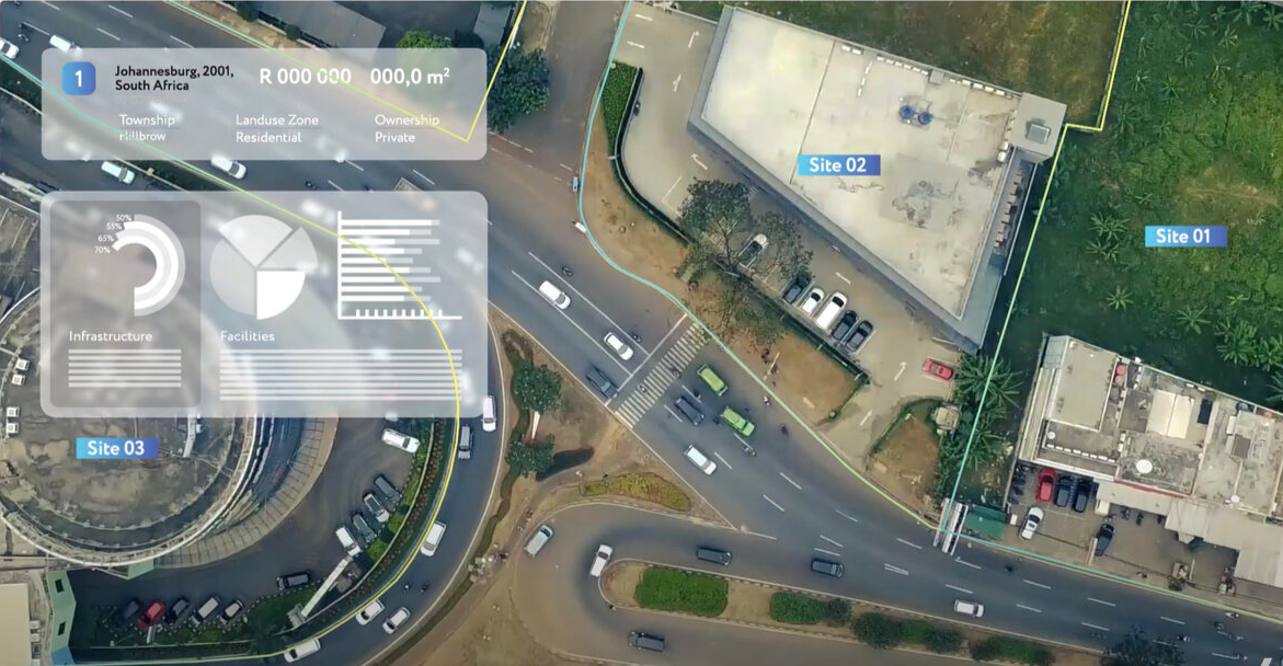
Specifically, we looked into the Planning London Datahub and Community Infrastructure Levy data.
We investigated additional external factors like the Bank of England Interest Rate, Index of Multiple Deprivation, and Price Paid Data to identify requirements for building a reliable machine-learning model.
The model will help London Boroughs and utility companies make strategic decisions on allocating and prioritising their investments to deliver housing quicker and with minimum disruptions.

Advancements in capturing new spatial data and public access to GIS systems, enriched with updated planning policies and land records, promise a new level of transparency to market stakeholders, facilitating coordinated efforts in urban development.
However, the reality on the ground often proves different. Information about land and property remains unevenly distributed and frequently challenging to acquire. Data stewards often lack incentives to make their data readily available and user-friendly, providing professional services companies with additional business and, therefore, a motivation to maintain the status quo. In this situation, property developers are forced to follow well-established paths, lobbying authorities and local communities despite numerous innovations in city plans.
Speakers explored the role of the data for experienced property investors, the decision-making process, and innovations in planning and implementation challenges.
The discussion focused on the role of professional services companies in aligning policy intentions with individual property development strategies. These companies ensure that broader policy goals are met through specific development projects.
Speakers:
Prof. Philip Harrison
South African Research Chair in Spatial Analysis and City Planning, WITS University
Minenhle Maphumulo
Strategic Planner, City of Johannesburg
Katherine Cox
R&D and Development Impact Manager, TUHF21
Yuriy Milevskiy
CEO, OneCity; Co-founder, Novaya Labs

“In the markets we focus on, data that helps inform the decision-making process regarding where to invest is not always readily available. This sees us relying predominantly on word-of-mouth and local knowledge from community members. Embracing technology like OneCity in addition to this enables uMaStandi to make informed decisions, guided by the integration of hard facts and local insights,” says Katherine Cox, Development Impact Manager at TUHF21.
OneCity addresses this through a solution tailored for the unique business case of TUHF21. Our solution is giving them access to everything from socio-economic data, planning data, and infrastructure accessibility data to empower them to make better strategic decisions on where to expand in targeted townships,” says Yuri Milevskiy, Founding Partner at NOVOYA Labs.
NovayaLabs and our partners will present OneCity to an audience of investors, collaborators and clients at the Urban Links Africa public showcase on 11 March 2021. We will be joined by guest speakers from the public and private sectors who will share their vision for the future of the UK – African trading relationship and the opportunities that digital solutions present.
Learn more about OneCity and sign up to experience the beta version here.
Find out why we think OneCity is the tool to tackle sustainable mobility challenges in the world’s fastest growing cities, here

Saturday, 6th March ___ Novaya CEO, Yuriy Milevskiy, will be in conversation with James Maddison, Content Leader for the ODI’s Open Innovation in the UK public sector campaign, as part of a panel organised by the Hazards Forum to mark International Open Data Day.
Yuriy and James will discuss obstacles to the use of open data in land development and potential solutions to these challenges. They will share insights from their experience in the field and answer audience questions about the risks and benefits of adopting open data initiatives.
Reserve your place here.
Open Data Institute works with companies and governments to build an open, trustworthy data ecosystem, where people can make better decisions using data and manage any harmful impacts.
Hazards Forum was established in 1989 by the four major engineering institutions, the Institutions of Civil, Electrical, Mechanical and Chemical Engineers to provide an interdisciplinary focus for the study of disasters and the promulgation of lessons learned from them.

NOVAYA and our South African partner Wits Enterprise // SaRCHI in Spatial Analysis and City Planning join 6 other partnerships that Urban Links Africa will support to deploy their digital solutions to address urban challenges in some of Africa’s most rapidly emerging cities.
Over the next 5 months we will be refining our digital planning tool NOVAYA IAT to address the challenge of sustainable mobility in Johannesburg. You can learn more about our winning solution here.
Being part of Urban Links Africa doesn’t just mean funding to expand NOVAYA IAT to new cities. We will also have access to a unique support network, including workshops with key UK Government departments, 1-2-1 support from a South African urban expert, and the guidance of a Business Advisory Board of representatives from large businesses and the investment community.
You can find out more about Urban Links Africa here: www.urbanlinksafrica.com

Subject to local government approval of administrative regulations on using particular software for building facade oversight, this tool substantially simplifies the implementation of policies regulating street front design. In addition, the tool can prevent violations and acquaint the public and building owners with the standards for building facades.
The formation of a locality’s identity via urban planning is a long-term process. Development takes decades, if not centuries, even when it comes to systematically renovating a city’s districts. The aesthetic style and spatial characteristics of buildings change slowly. The emergence of new, iconic pieces of architecture is also an infrequent occurrence. How can one embark upon the establishment or discovery of a city’s identity in real time, in the short term?
Our latest project seeks to use the architectural regulation of buildings and structures as the most effective way to establish a city’s identity in the short term.
Taking cities in the Moscow region as examples, we developed several tools for architectural design regulation:
- Urban-planning regulations in land use and development codes as the only proper mechanism for establishing architectural design requirements, since the limits of their jurisdiction are shown on a territorial zoning map and information about them is part of Russia’s Unified State Register of Real Estate;
- Additional information layers for a regional geographic information system (the Moscow region geoportal) that contain data sets about a place’s composition and characteristics, making it possible to not only program changes, but also increase the quality of project design solutions in a specific area;
- A digital toolkit for monitoring the compliance of municipally-owned buildings and apartment houses undergoing major renovations with architectural design standards;
- Methodological recommendations and implementation procedures for local authorities.
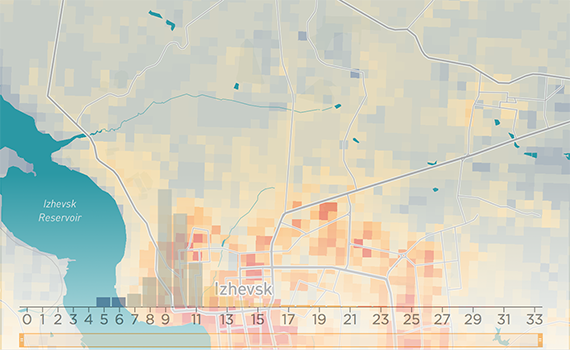
The city of Izhevsk, Russia, with a total population of 649,500 people, has suffered from the dramatic impact of rapid urban sprawl. In recent years, the built-up area has grown by more than 12.5%, with even more noticeable growth in the suburban region.
Existing planning documents were regularly updated retrospectively to reflect planning permissions granted, subverting the planning process overall. This resulted in new housing districts built on former agricultural land without essential social infrastructure.
By 2017, local and regional governments faced significant reputational damage due to a lack of transparency in the decision-making process and the significant shortage of local social infrastructure.
Izhevsk has very low housing availability – 21.5 sq.m./per person – the lowest in the Volga region and lower than the Russian average of 23.4 sq.m./per person. 2025 housing targets for Izhevsk aim for 3,005 mln. sq.m. of new housing to be built. Meanwhile, the current housing stock is only 13,570 mln sq.m. meaning the city is about to grow by more than 20% in less than five years.
There is a significant shortage of local social infrastructure in Izhevsk. The daycare shortage (calculated according to the local Planning Policy Guidelines) amounts to 9,400 places in Izhevsk and 1,060 in the suburban area. The total shortage of places in schools reaches 15,343. In many cases, new housing was not followed by new social infrastructure. This created a spatial imbalance with an overprovision of social infrastructure in the city centre and a lack of it in the periphery.
To resolve these challenges we used IAT© as the backbone for developing, monitoring and updating the city’s 2030 Spatial Strategy. This allowed us to:
- Identify imbalances in the urban mix by quantifying current and future shortages of social infrastructure and utilities;
- Communicate efficiently with real estate developers and local citizens using an identical set of information in simple visual form;
- Set indicative floor area targets for different uses and model city-wide impact;
- Use the tool as a universal medium for further reviews of planning documents and monitoring of their implementation.
The IAT© measures the provision of infrastructure — from social to recreational — in different parts of the city. The tool helps residents and businesses participate in city planning via an interface equipped with data. Integration of IAT© with regional and municipal GISs enables a transition from opaque decision-making to an open process with quantifiable results. To learn more about IAT© see our demo here.

Under the leadership of NOVAYA (Russia/UK), the multidisciplinary team consisted of Mae Architects (UK), APRELarchitects (Russia), Groupe Huit (France), West 8 (Netherlands), and the Higher School of Economics (Russia).
Based on the guiding principle of a “vibrant city”, the project includes a development concept for Derbent’s 12-kilometre embankment and a detailed plan for initial construction along a 2.5-kilometre priority section.
The city of Derbent is 121 kilometres southeast of Makhachkala, capital of the Republic of Dagestan in the Russian Federation. Derbent is Dagestan’s second-largest city and one of the oldest cities in the world. It is located on the western shore of the Caspian Sea, on the foothills of the Tabasaran Mountains of the Greater Caucasus, and stands at the closing point of a narrow coastal strip known as the Derbent Passage or the Caspian Gates. The historic city centre is listed as a UNESCO World Heritage Site for its citadel, ancient town, and fortress buildings.
Derbent’s coastal setting, favourable climate, natural resources, cultural heritage, and strategic importance make it a development priority with outstanding potential. The NOVAYA consortium master plan will help the city build a foundation for medium-term socio-economic and spatial development. Besides charting a course for Derbent’s internal transformation, the plan will help the city become a catalyst for Dagestan’s fuller integration into the federal and international economies.
The competition was administered by the “I Love Derbent” charity foundation and organised by the CENTER Agency for Strategic Development. The other two shortlisted teams were led by IND Architects and the Genplan Institute of Moscow, respectively.

Didier Vancutsem, Director of the International Society of City and Regional Planners (ISOCARP) and co-author of UN-Habitat’s New Urban Agenda and City Prosperity Index, discussed linking, monitoring, and optimising supranational urban development objectives and performance indicators.
Dr Pietro Elisei, Director of URBANSOFIA, provided examples of applying indicators in regional and municipal documents, emphasising the central role of connecting OECD development indicators with EU financing.
Aleksander Sergeevich Puzanov, Director of the Institute for Urban Economics (IUE) and one of the key contributors into Perm Masterplan, outlined the complexities of applying indicators at the municipal level in the Russian Federation — particularly the incongruity of spatial planning documents with objectives and indicators for socio-economic development strategies, municipal and federal programs. The discussion also touched upon problems associated with indicators for Russia’s National Priority Projects adopted in 2018, their connection with national objectives, and KPIs at the regional and municipal levels.
According to discussion participants, the future of urban development and performance indicators is defined by the following:
Clearly distinguishing between criteria for achieving national objectives and local performance indicators. That is, recognising the difference between outcome and output.
Synchronising objectives and indicators in documents for socio-economic and spatial development; namely, a precise conversion of socio-economic development tasks and related performance indicators into trackable indicators for spatial planning documents, and vice versa.
Defining a set of unique indicators that meet the challenges of a particular city, as well as assuring that these indicators coincide with higher-level goals.
Tracking performance of planning policies as a key factor in achieving long-term goals.
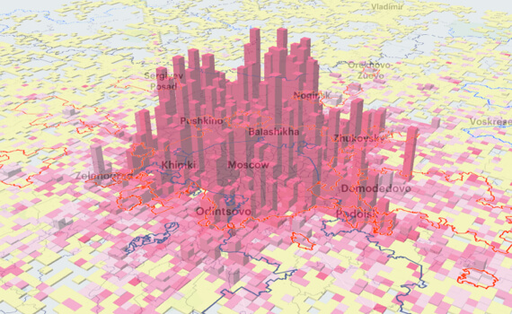
The research covers such megacities as London, Seoul, Tokyo, Beijing, Shanghai, New York, Moscow and Buenos Aires. All of them face unique development challenges within complex social and political frameworks while they are comparable in terms of population.
We have also reviewed a number of rapidly growing agglomerations (1.5 to 5 million residents): Milan, Lyon, Auckland, Copenhagen-Malmo, Montreal and Brisbane. Several metropolitan areas in Russia with advanced governance arrangements were introduced as a part of the study: Saint-Petersburg, Kazan, Novosibirsk, Ekaterinburg, Rostov-on-Don, Makhachkala-Kaspiysk, Perm, Samara-Tolyatti and Vladivostok.
At the pre-design stage, we have analysed physical and legal planning constraints, the current quality of the facilities, the transit routes, the landscape and visual impact and other aspects. 400 verified responses to our online survey pointed out the most frequently used facilities as well as the crucial problems that local residents face while visiting the park. According to the survey, the park is often perceived as unsafe, out-of-date and confusing to move around. At the moment it lacks well-maintained spaces for cultural and sports activities, basic service facilities and accessibility of the waterfront. Moreover, the publicly and privately owned parts of the territory appear to be fully disintegrated. Based on the pre-design analysis and survey results we have identified the areas requiring intensive development and those needing limited renovation.
Sociological analysis remained our primary tool throughout the project. Along with the online survey, over fifty residents were consulted via individual and group interviews on whether the park met the needs of their families and what kind of facilities they would like to be introduced there. The interviews and the survey helped to define a long-list of 39 facilities that were later put up for a final open vote. 300 residents gave their votes for the facilities in each of the six categories: activities for children, culture, sports, nature and recreation, entertainment, food and services. We integrated the most favoured objects and facilities into the service model for the park.
According to the developed strategy, the park will offer multiple cultural, sports and recreational activities all year round.These include skating, skiing, wall climbing, picnicking, reading, sunbathing and many others. The lighting, street furniture and pavement will be replaced or reconstructed to create comfortable and safe public spaces. This specifically relates to the entry groups, jogging and cycle paths and waterfront areas. The park administration will resume the maintenance of the wild green areas. Various kinds of food services, as well as access to emergency medical assistance, will ensure longer hours spent in the park. We are already conducting negotiations with local entrepreneurs willing to locate their services there.
Over the course of renovation, our client is planning to bear capital expenditures of more than 300 million rubles. Around 20 million rubles of yearly operating expenses will be covered by local administration.
