
Outer London and town centre network
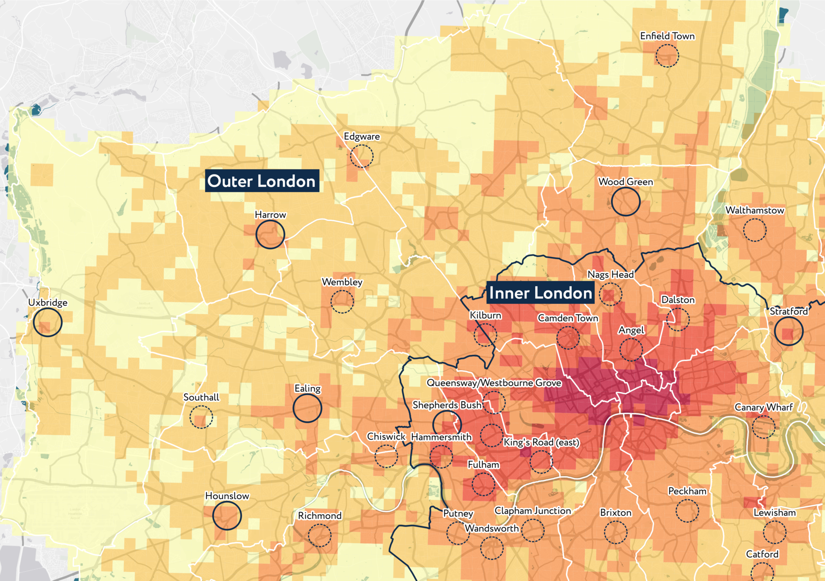
The London Plan says that Outer London's "economic performance has given rise to concerns that it may have been relegated to a 'dormitory' role and that its economy and infrastructure provision have been neglected" (2.26). Our research confirms that; the infrastructure provision in Outer London is at a significantly lower level than in Inner London (20 in Outer London vs 47 in Inner London, out of a possible 100). However, the difference between borough territories can be significant, and we identified areas that have better access to infrastructure in every borough, comparing them to town centre locations in the London Plan.
The London Plan identifies several important Metropolitan and Major Centres in Outer London, designating them as key spatial priorities and means of support to a polycentric city structure, naming them "key locations for a diverse range of activities, including retail, leisure and office space as well as housing, social infrastructure and public open space" (2.70). We established that necessary types of infrastructure (schools, daycare and everyday shops) are better represented in Metropolitan Centres in Outer London, and there is "considerable potential for growth in the leisure, cultural and visitor economy sectors, with scope for encouragement of cultural quarters in outer London – particularly in town centres" (2.35), confirmed by the lack of social and optional types of infrastructure. Through our research, we can prove their exact locations and boundaries, compare them and identify their challenges and benefits in terms of different infrastructure types.
The London Plan identifies several important Metropolitan and Major Centres in Outer London, designating them as key spatial priorities and means of support to a polycentric city structure, naming them "key locations for a diverse range of activities, including retail, leisure and office space as well as housing, social infrastructure and public open space" (2.70). We established that necessary types of infrastructure (schools, daycare and everyday shops) are better represented in Metropolitan Centres in Outer London, and there is "considerable potential for growth in the leisure, cultural and visitor economy sectors, with scope for encouragement of cultural quarters in outer London – particularly in town centres" (2.35), confirmed by the lack of social and optional types of infrastructure. Through our research, we can prove their exact locations and boundaries, compare them and identify their challenges and benefits in terms of different infrastructure types.
Explore the map
IAT© can be integrated into existing urban planning systems in order to assess urban policy implementation and formulate place specific development programs. Explore the map with IAT© index layers corresponding to London Plan town centres, opportunity areas, brownfields and more.
Let's talk
Tell us how we can help you